There is a ton of construction going on in South County right now. For the next few years, South County residents will need to deal with construction on I-5 at Avenida Pico, Ortega Highway and El Toro just for starters. We will also watch as the Rancho Mission Viejo transportation infrastructure is built out over the next decade or so, including Cow Camp Road. And finally, we will bear witness as the 241 Extension either rises from the ashes or is mercifully put out of its misery, once and for all. In short, there are many reasons for South County residents to care about transportation related issues and there is an opportunity for you to make your voice heard. The OCTA is seeking public input on its draft Long Range Transportation Plan, called Outlook 2035. The public is encouraged to attend a meeting tonight, May 7, at OCTA Headquarters to express its opinions. More information is available here, or below:
Draft Long Range Transportation Plan looks at mobility for the next 20 years in Orange County with public meeting planned for May 7
ORANGE – The Orange County Transportation Authority is seeking public input to help plan for the county’s transportation needs for the next 20 years.
A draft copy of the Long Range Transportation Plan, called Outlook 2035, was presented to the OCTA board at a recent meeting and is now up for public review and comment on the website at: www.octa.net/lrtpdraftplan.
A review period will follow with an open house to solicit more input on the plan scheduled for 5 to 7 p.m. on May 7 at OCTA Headquarters, 550 S. Main Street in Orange.
“This is a document that will direct how we improve mobility for Orange County for the next two decades, looking at a wide range of transportation modes – from freeways to bicycles,” said OCTA Chairman Shawn Nelson, also the county’s Fourth District Supervisor. “We need the public’s input to ensure that we’re developing the best ways to keep residents, workers and visitors moving,”
Every four years, the OCTA completes a Long Range Transportation Plan that examines the county’s expected transportation needs, accounting for changes in demographics, the economy and available funding.
The plan also explores potential trends in the way people travel through the county as the population changes and looks at a multiple transportation modes, including buses, trains, freeways, city streets, bikeways and more.
During the next 20 years, Orange County’s population is expected to grow by about 400,000 people, adding to the demand on the local transportation system.
The plan addresses key issues such as the fact that transportation demands are outpacing capacity, that existing infrastructure needs improvements and that funding is unpredictable.
The Measure M program, the county’s half-cent sales tax for transportation, is the centerpiece of long-range planning. The Long Range Transportation Plan includes Measure M projects and looks beyond at additional needs throughout the county.
In comparison to transportation systems that existed as of 2010, the plan calls for the addition of:
- New bus and streetcar service on key, high-demand streets
- Enhanced bus routes to maintain on‐time performance
- 20 weekday Metrolink trains
- 650 miles of bikeways
- 820 lane miles on the Master Plan of Arterial Highways
- 200 freeway/carpool lane miles
- 242 tollway lane miles
- 450 vanpools and station vans
The draft plan includes many suggestions based on initial input from the public, including:
- Optimize – Make better use of what we have by synchronizing traffic signals, widening major intersections, improving transit connections and improving conditions in carpool lanes.
- Maintain – Preserve existing streets and roads, and fix potholes.
- Educate – Inform the public about public transportation and non-motorized transportation options, and develop bicycle and pedestrian safety programs.
- Innovate – Develop faster mass transit solutions and include innovative solutions, such as real-time passenger information and electronic ticketing to encourage transit use.
- Collaborate – Communicate within and across county borders to develop regional solutions and connections.
After the public review period, which lasts through June 20, necessary revisions will be made to the draft plan. It is then expected to go before the OCTA board for approval in September. The Long Range Transportation Plan will then be submitted to the Southern California Association of Governments, where it will serve as Orange County’s input into the Regional Transportation Plan.
For more information, visit octa.net/lrtpdraftplan.
The prediction for traffic in twenty years is grim. If you think it’s bad now, imagine this. According to the draft plan (large PDF):
“Without further improvements, by 2035 in the morning peak period, nearly every freeway will be congested…approximately 27% of the freeway system in Orange County will be consistently congested, while 29% will be severely congested. In fact, every freeway is projected to have segments of severe congestion, most notably along I-5 in both the southern and central regions of the County.”
Part of the reason for this is population growth, particularly in areas underserved by the existing freeway and arterial highway system. According to the OCTA, most of the County’s population growth over the next 25 years will occur inland, and is clustered around North County (Fullerton, Anaheim and Orange), inland Irvine/Lake Forest (where a number of large developments are planned) and Rancho Mission Viejo. The graphic below illustrates where this population growth is likely to occur in comparison to the existing roadways.
Needless to say, the population growth expected to occur around the Ranch Plan is most alarming because there isn’t a single freeway anywhere near the new residents. Indeed, we can’t remember any residential development of this size, so isolated from the County transportation infrastructure. Every single one of those new residents is going to have to travel miles of surface streets to access a freeway. Not only that, but there is no single surface street — an arterial highway, in OCTA-speak — that will make the trip. Indeed, these residents will be lining up to make right and left turns on Cow Camp, Antonio, Crown Valley, Oso, Ortega and La Pata. There’s no mystery what the end result of this is going to be — we’ve been predicting congestion on Cow Camp Road since November 2012. In that article, we said:
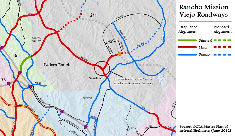
Have you driven Antonio Parkway between Covenant Hills Drive and Ortega Highway lately? If so, you have probably noticed some changes. Gone is the unobstructed downhill drive towards to Ortega — that stretch of Antonio where you could easily hit 70 if you weren’t paying attention. Freshly landscaped, Antonio is now punctuated with new stop lights and intersections. As you head south, first up is a new intersection between Antonio and a new street called Sendero. Just beyond that is a big gaping hole where the terminus of Cow Camp Road will intersect with Antonio Parkway. These two roadways are just the beginnings of a network of roads that will collect and distribute traffic resulting from the Rancho Mission Viejo buildout. You can see all of the current and planned road alignments in and around Rancho Mission Viejo below:
The map above is an excerpt from the larger OCTA map showing all established and proposed alignments of Orange County’s arterial highways. The highways are color coded to indicate how much traffic they are designed to handle. Principal highways (green) are the busiest, followed by major highways (red) and primary highways (blue). Secondary (or collector) roads are shown as a thin black line and freeways (including the current and proposed toll roads) are shown as a thick grey line. Note that the solid lines don’t necessarily mean the roads are built, but only that the alignments are approved — for an example, see the segment of La Pata where the gap currently exists. Broken lines are merely proposed alignments, subject to change. We’ve annotated some of the roads in the map above, as well as indicating where Ladera Ranch and the Village of Sendero are located. The full PDF of the Orange County Master Plan of Arterial Highways is available from the OCTA here.
We’ve circled the intersection of Cow Camp Road and Antonio Parkway for you. What do you see there? We see a major arterial highway (one that is expected to eventually carry 30-45,000 cars daily) coming to an abrupt dead-end at Antonio Parkway. Those 30-45,000 cars are in all likelihood, heading for the 5 freeway. They either need to make a right turn on Antonio, travel northbound through Ladera, cue up for a left turn on Crown Valley and further choke Crown Valley between Antonio and the 5. Or they will cue up for a left turn on Antonio, head south, make a right on Ortega Highway and further choke traffic on Ortega Highway between Antonio and the 5. In one scenario, Mission Viejo suffers. In the other scenario, San Juan Capistrano suffers. In both scenarios, Ladera Ranch suffers. The County transportation planners seem to think it will be the first option, but we’re not so sure. Even if drivers split 50/50 between Crown Valley and Ortega, neither of those roadways has the extra capacity to absorb a 50% or greater increase in daily traffic. Now granted, we probably have twenty years before Rancho Mission Viejo is built out and Cow Camp is operating at full capacity, but drivers on Antonio who see an eight lane highway dead-ending into Antonio have to wonder “where are all those cars going to go?”
Our concerns then seem to remain true today. The only solution seems to be a 241 connection to the 5 freeway, and that seems about as likely as Zorro returning to San Juan Capistrano. What does the OCTA Long Range Transportation Plan say about a 241 connection to the 5?
Fifth District Supervisor Patricia Bates wrote about this in her May column in the Ladera Times. A link to the entire May issue is here (large PDF). We can’t link to individual stories in the Ladera Times, but Bates’ column is on page 8. Supervisor Bates discusses the debate over whether to continue to include a 241 connection in the long range plan:
Over the last several weeks, there has been significant discussion whether to continue to include the SR-241 Completion Project in the LRTP because of the recent devision by TCA to rescind the 2001 Federal Notices of Intent (NOI) for preparation of a Federal Environmental Documentation for the proposed alignment. The rescission of the Federal NOI was initiated given the SR-241 project alignment south of Cow Camp Road to I-5 is undetermined at this time. A potential new alignment must be reviewed and evaluated before the Federal Environmental Documentation is again initiated.
Supervisor Bates believes that the SR-241 should remain a part of the County’s long range transportation plan because “there is a critical need for the project as a north-south alternative to I-5.” A look at the anticipated population growth along a future 241 alignment emphasizes that point. And to be clear – that population growth is coming with or without the 241.
In discussing the complex traffic problems that Orange County faces Supervisor Bates says that “[t]he other party of the solution is completing the 241 Toll Road to its planned terminus at the I-5 freeway by developing an alternative alignment that addresses the expressed environmental concerns.”
Below is the 2035 Preferred Scenario for Regional Highway Improvement Areas according to the draft Plan. As you can see, the 241 survives for now — at least on paper:
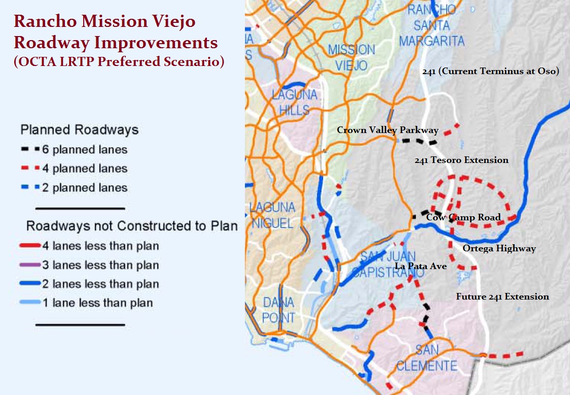
Below, we’ve excerpted the roadway improvements in and around Rancho Mission Viejo from the 2035 Preferred Scenario:
Note the extension of Crown Valley Parkway to the future Tesoro Extension of the 241 (between its current terminus as Oso Parkway and the proposed interim terminus at Cow Camp Road. This is part of the conceptual plan, which means long-range projects that OCTA would like to pursue if the funds were available. OCTA is calling that a “SR-73/I-5 to SR-241 Connector Road” and it will be designed to carry traffic between the coastal 5/73 freeway system and the inland 241/261 toll road system. The conceptual plan calls for construction of a new 241/Crown Valley interchange. While this Crown Valley extension may not occur within the time frame of this long range plan, it is worth thinking about as an alternative to a 241/5 connection. In the event that the 241 never progresses beyond Cow Camp, the future Crown Valley Parkway stands to become a de facto freeway of its own.
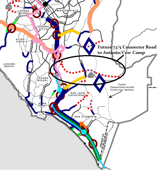
Even worse, the conceptual plan still includes a ”four-lane limited access road connecting both I-5 and SR-73 to Antonio Parkway and Cow Camp Road” in San Juan Capistrano. There isn’t much detail in the current draft Long Range Transportation Plan, but an excerpt from this map from 2008 shows the same roadway and its possible alignment:
Egads! That’s a four lane freeway that runs right over the top of Sendero! Now granted, this document is from 2008 — before Sendero was built. It’s one thing to build a freeway through farm land, it’s another to build it through a residential community. But in spite of Sendero now being built, this connector road is still part of the conceptual project list contained within OCTA’s current draft Long Range Transportation Plan. Residents of Ladera Ranch, Rancho Mission Viejo, Sendero, Gavilan and San Juan Capistrano are all going to want to keep their eyes on this.


Recent Comments