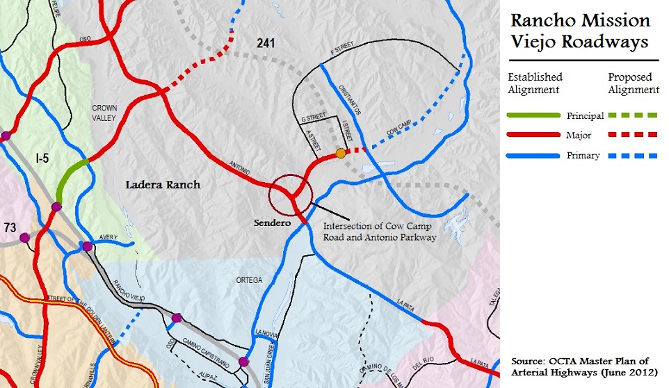
Have you driven Antonio Parkway between Covenant Hills Drive and Ortega Highway lately? If so, you have probably noticed some changes. Gone is the unobstructed downhill drive towards to Ortega — that stretch of Antonio where you could easily hit 70 if you weren’t paying attention. Freshly landscaped, Antonio is now punctuated with new stop lights and intersections. As you head south, first up is a new intersection between Antonio and a new street called Sendero. Just beyond that is a big gaping hole where the terminus of Cow Camp Road will intersect with Antonio Parkway. These two roadways are just the beginnings of a network of roads that will collect and distribute traffic resulting from the Rancho Mission Viejo buildout. You can see all of the current and planned road alignments in and around Rancho Mission Viejo below:
The map above is an excerpt from the larger OCTA map showing all established and proposed alignments of Orange County’s arterial highways. The highways are color coded to indicate how much traffic they are designed to handle. Principal highways (green) are the busiest, followed by major highways (red) and primary highways (blue). Secondary (or collector) roads are shown as a thin black line and freeways (including the current and proposed toll roads) are shown as a thick grey line. Note that the solid lines don’t necessarily mean the roads are built, but only that the alignments are approved — for an example, see the segment of La Pata where the gap currently exists. Broken lines are merely proposed alignments, subject to change. We’ve annotated some of the roads in the map above, as well as indicating where Ladera Ranch and the Village of Sendero are located. The full PDF of the Orange County Master Plan of Arterial Highways is available from the OCTA here.
We’ve circled the intersection of Cow Camp Road and Antonio Parkway for you. What do you see there? We see a major arterial highway (one that is expected to eventually carry 30-45,000 cars daily) coming to an abrupt dead-end at Antonio Parkway. Those 30-45,000 cars are in all likelihood, heading for the 5 freeway. They either need to make a right turn on Antonio, travel northbound through Ladera, cue up for a left turn on Crown Valley and further choke Crown Valley between Antonio and the 5. Or they will cue up for a left turn on Antonio, head south, make a right on Ortega Highway and further choke traffic on Ortega Highway between Antonio and the 5. In one scenario, Mission Viejo suffers. In the other scenario, San Juan Capistrano suffers. In both scenarios, Ladera Ranch suffers. The County transportation planners seem to think it will be the first option, but we’re not so sure. Even if drivers split 50/50 between Crown Valley and Ortega, neither of those roadways has the extra capacity to absorb a 50% or greater increase in daily traffic. Now granted, we probably have twenty years before Rancho Mission Viejo is built out and Cow Camp is operating at full capacity, but drivers on Antonio who see an eight lane highway dead-ending into Antonio have to wonder “where are all those cars going to go?”
There are lots of traffic related questions about the Ranch Plan, including when the La Pata Gap will be closed, when the various phases of the 241 extension will be finished and whether the 241 will ever connect to the 5, but the design of Cow Camp Road is unusual. Nowhere else in Orange County does a major highway come to an abrupt end like this, forcing all of those cars to wait for left and right turn signals. It is bound to be a point of congestion — indeed it seems designed to create a bottleneck. And don’t forget, all the Ladera traffic that currently drives unobstructed on Antonio Highway will have to stop at not one, but two new stop light intersections between Covenant Hills Road and Ortega. Add to that all of the traffic entering and exiting the neighborhood retail center at the corner of Ortega and Highway and this area has the makings of a traffic nightmare.
None of us moved to this area because we want to fight gridlock every time we tried to leave our homes. We’re sure there are reasons why the Ranch Plan roads were designed the way they are, and why other alternatives (like turning Christianitos into a highway loop that fed Crown Valley from the north and Ortega from the south) were not selected. It’s also possible that the 241 will relieve some of the commuter traffic resulting from the Rancho Mission Viejo development, lessening the impact on surrounding arterial roads. We hope so — our quality of life depends on it.


Recent Comments